|
Along the winding road and not much further Michael parked on the side of the road in the middle of what seemed to be nowhere. This was it, and I searched for some sort of a sign. Eventually I spotted a very small faded sign nailed to a utility pole, facing the opposite direction, which stated "Quashies River Caves" with an arrow pointing to the bush down a slope. This is a sign designed to be missed.
We followed the track down the hill, at first a grassy open space, which led to bushes and then trees. Michael told me that this property is Bristol Farm, a former coffee plantation, now in receivership and no longer in operation. Within a few minutes, there was a soft sound of water and Michael announced that we were there. I was puzzled as I saw no caves, no river, and no waterfalls.
Michael grinned and led me a few feet from the path and told me to look down. It was hard to believe. Through the bushes I could see a huge cavern, and looking down, I could see that it was a sheer drop of about a hundred or more feet to the stream, glistening in the sunlight which filtered through the tall trees surrounding the opening and effectively camouflaging it (see photo below).
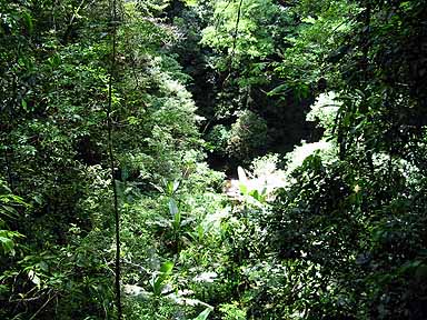
The cavern through the trees from the trail
At the edge of the cavern, I could feel the cool damp air from below, contrasting with the hot harsh midday heat on our path. Two steps in the wrong direction, and I would be over the edge. This is dangerous. There is no safety rail, no signs of warnings. And the only way to get down to the river at the bottom of the cavern is by using the two old rusted metal ladders fixed to the sheer face of the cliff.
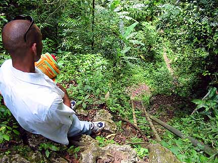
Michael on edge of rock at the top of the first ladder. Water pipe to the right.
This is not for the unfit. Navigating down the first ladder was hard enough but going from one ladder to the next was more tricky. Carefully, carefully. Then on the floor of the cavern, we had to pick our way down the side of the hill to the bank of the stream.
BACK NEXT
Introduction : Comfort Hall, Hiking Trail Up Caledonia Hill, German Town, Jelly Coconuts, Top Of The Cavern, Natural Waterfall, Dam Waterfall, The Caves, Cavern Greenery, Further Reading
|